
I have been thinking recently of Lehi's family's sea voyage to the promise land. The Book of Mormon has some details about Lehi's family's transit through the wilderness and there is a lot of speculation on the internet on their route. But there is really no information on their route across the sea. I am not a bible scholar and do not know too much about the location that they landed but I do know a little something about the sea. I was the navigator on a US Navy submarine and I have transited through most of the Pacific and Indian Oceans and have transited most of the likely sea routes taken by Lehi's family. How I see it, there are four MAIN routes that they could have taken -- there are of course thousands of variations of these routes and they could have taken any combination of these. The thing to remember through all of this is that they were lead by God. They were not proficient sailors, and their ship was designed by God so there are many unknowns. I will break them down the possible routes here shortly but first some background information.
 |
| Possible Routes: 1. South Ocean Route 2. Torres Strait 3. Lombok Strait-Philippine Sea 4. Strait of Malacca - Luzon Strait |
Strait of Malacca - Luzon Strait 15,000
Lombok Strait - Philippine Sea 14,500
Torres Strait 14,000
Southern Ocean 12,000

So How Fast Can They Sail?

With sailing it is easier to think in terms of distance sailed in 24 hours than instantaneous speed since winds direction and speed can change suddenly. For modern day sail boats with a proficient
crew and the following numbers are sustainable. Any run of less than 100 miles in
24 hours is depressing (less than ave 4.1 knots) but not unusual in low wind
conditions. (These are also straight line figures where as 100 miles made good
to windward might be considered good going.) 120 miles a day is good progress.
(5 knots average) 150 miles a day (6.25 kts) is dream stuff.
If you look at historical mariners
you get the following:

- Columbus took two months, 9 days. Aug.3-Oct.12.
- The Mayflower took two months, 4 days. Sept.6-Nov.10
From Europe to the new world is approximately 3000 miles. So 3000 miles / 70 days = 43
miles a day. Less than 2 kts average.
Of course with God all things are possible they could have been given "fair winds and following seas" the entire way to the americas. But I don't think this is the case. We were sent here to earth to learn and to grow so I bet they had more like Mayflower numbers (43 miles a day) and probably even worse, than they would have had of modern day "dream stuff" numbers of 150 miles a day.
Putting this in tablular form with the following three speeds: Mayflower ( 43 miles a day), Average (100 miles a day), and Dream Stuff (150 miles a day) we get the following durations of transit.
Route Mayflower Average Dream Stuff
Strait of Malacca - Luzon Strait 349 150 100
Lombok Strait - Philippine Sea 337 145 97
Torres Strait 326 140 93
Southern Ocean 300 129 86
So their journey would have taken them anywhere from 86 days (3 months) to almost a year or longer. Which leads me to the next question.
What About Provisions?
Here are some rough numbers for water the big limiting factor for supplies.
- Per emergency preparedness sites a person needs to have around 1 gallon of water a day. That is 2 quarts for drinking and 2 quarts for sanitation and food preparation.
- Most people in the US use on average 100 gallons of water a day.
- Most people with sail boats use around 5 to 15 gallons of water a day.
 |
| 13.5 cubic ft freezer |
So what does this mean? We do not know the number of people in Lehi's company but just for easy math lets say there were 100 people and they used 10 gallons a day. I bet they learned in the wilderness to conserve water and were very stringent on its use so it might be more around 5 gallons a day but then I think of the fact that they had kids along (and kids use a lot of water). Adding this up what we get is that they used 1,000 gallons of water a day.
So if they transited the quickest route, the Southern Ocean, at "Dream Stuff" speeds they would use 86,000 gallons of water. If you assume the emergency preparedness numbers, then they would need 8,600 gallons. So how much space would this take up? 100 gallons is approximately 13.5 cubic feet roughly the size of a freezer.
So this means that they would need to store 86-860 of these freezer sized volumes of water just to get to the promised land. This is just the water that they would need, this does not take any account of the amount of food that would need to be stored. Also this is for the fastest route at the fastest speed. The other extreme, the Strait of Malacca - Luzon Strait at Mayflower speeds they would need 349,000 gallons of water or they would need to store 34,900 of these freezer sized containers for their journey.
This leads me to the conclusion that they must have made plenty of stops along the way. If you look at the routes they could have taken, almost all of the routes pass by land along the way.
The Different Routes
Strait of Malacca:
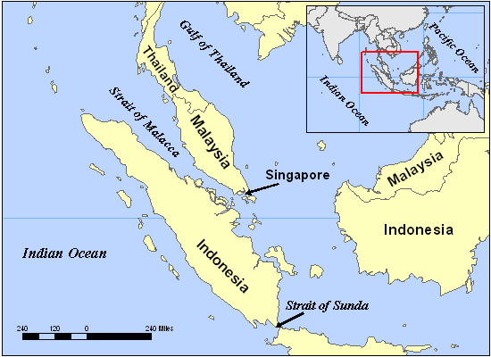
The
Strait of Malacca is a narrow, 500 NM stretch of water between the Malay
Peninsula and the Indonesian island of Sumatra. The Strait of Malacca is one of
the most important shipping lanes in the world. The strait is the main shipping
channel between the Indian Ocean and the Pacific Ocean, linking major Asian
economies such as India, China, Japan and South Korea. Over 50,000 vessels pass
through the strait per year, carrying about one-quarter of the world's traded
goods including oil, Chinese manufactures, and Indonesian coffee. At Phillips
Channel close to the south of Singapore, the Strait of Malacca narrows to 1.5
NM wide, creating one of the world's most significant traffic choke points.
When
I went through the strait, wind and current were not a noticeable factor. We went through during the rainy season and
would get microburst downpours that would dump rain for a couple of hours and
then clear up. Overall this was a very
beautiful and enjoyable transit. It is
also the quickest and easiest route between the Indian Ocean and the
Pacific. It was
The
Malay Penisula and Sumatra appear to have been inhabited during Lehi’s transit,
which means that they possibly could have traded for supplies and received replenishments.
Lombok Strait:

The
Lombok Strait is a strait connecting the Java Sea to the Indian Ocean, and is
located between the islands of Bali and Lombok in Indonesia Its narrowest point
is at its southern opening, with a width of about 12 NM. At the northern
opening, it is 25 NM across. Its total
length is about 40 NM. Because it is 250 m deep— much deeper than the Strait of
Malacca — ships that draw too much water to pass through Malacca often use the Lombok Strait, instead. The Lombok Strait is notable as one of the
main passages for the Indonesian Throughflow that exchanges water between the
Indian Ocean and the Pacific Ocean.

When
I went through the strait we observed a consistent 7 knot current from north to south
the entire time. During different times
of the day and during different seasons the current should shift with the tides. Because of the current, navigation could be
very difficult for a sail propelled vessel.
You would have to wait until the current shifted from south to south.
History
is not clear but this area probably was inhabited then Lehi’s family would have
transited through. Even today most
vessels seen in the area are subsistence fishermen.
Luzon Strait:

The
Luzon Strait is the strait between Taiwan and Luzon island of the Philippines.
The strait thereby connects the Philippine Sea to the South China Sea in the
western Pacific Ocean. The strait is approximately 160 mi wide containing a
number of islands grouped into two groups: the Batanes Islands of Batanes
province and the Babuyan Islands of Cagayan province, both of the Philippines. The strait is divided into a number of
smaller channels. The Babuyan Channel separates Luzon from the Babuyan Islands,
which is separated from the Batanes Islands by the Balintang Channel. Batanes
is separated from Taiwan by the Bashi Channel.
Torres Strait:
 |
| Torres Strait |
 |
| Liahona |
The strait links the Coral Sea to
the east with the Arafura Sea in the west. Although it is an important
international sea lane, it is very shallow, and the maze of reefs and islands
can make it hazardous to navigate. In the south the Endeavour Strait is located
between Prince of Wales Island (Muralug) and the mainland. I have never transited this route. The currents through here can be very large (two oceans ebb and flow through this little choke point. This strait goes through the Great Barrier Reef and this could be tough navigating to find a safe way through by mariners unfimiliar to the area. This area was most likely not inhabitied at this time. If Lehi's family went this way, they had to have been lead by the Liahonahona to get through safety.
Southern Ocean:
 |
| Southern Ocean |
The
Southern Ocean comprises the southernmost waters of the World Oceans, generally
taken to be south of 60°S latitude and encircling Antarctica. As such, it is
regarded as the fourth-largest of the five principal oceanic divisions. I have never been down there but I have
always heard how rough the seas are and how cold it is. This is the shortest distance to transit but
it requires the most open ocean transit.
It they stayed near the coast of Australia and New Zealand it might not be too bad of a route and they would have had access to fresh water and supplies.
Indian and Pacific Oceans:
In both the Indian and Pacific Oceans there are thousands of little islands that could have supported
 Lehi's family and given them relief along the way. Navigating through these can be hazardous. There are a lot of locations that you can run aground if you do not know where you are going or you can transit 10 miles by an island and not realize that it was even there. Lehi's group had to have been led by God to know the right way to go in order to get supplies and ensure that they did not get lost. They had to have faith in God that he was going to provide for them if and when their supplies were going to run out. They had to know that they were worth to receive His guidance by keeping His commandments.

Conclusion:
No comments:
Post a Comment